


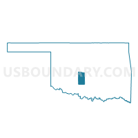
Voting District 12, Grady County, Oklahoma
About
Outline

Summary
| Unique Area Identifier | 654060 |
| Name | Voting District 12 |
| County | Grady County |
| State | Oklahoma |
| Area (square miles) | 13.98 |
| Land Area (square miles) | 13.96 |
| Water Area (square miles) | 0.02 |
| % of Land Area | 99.85 |
| % of Water Area | 0.15 |
| Latitude of the Internal Point | 35.13953380 |
| Longtitude of the Internal Point | -97.93972210 |
Maps


Graphs
Select a template below for downloading or customizing gragh for Voting District 12, Grady County, Oklahoma


Neighbors
Neighoring Voting District (by Name) Neighboring Voting District on the Map
- Voting District 21, Grady County, OK
- Voting District 27, Grady County, OK
- Voting District 35, Grady County, OK
- Voting District 6, Grady County, OK